
Section 8 Overview
Wells to Wendover - 113 miles
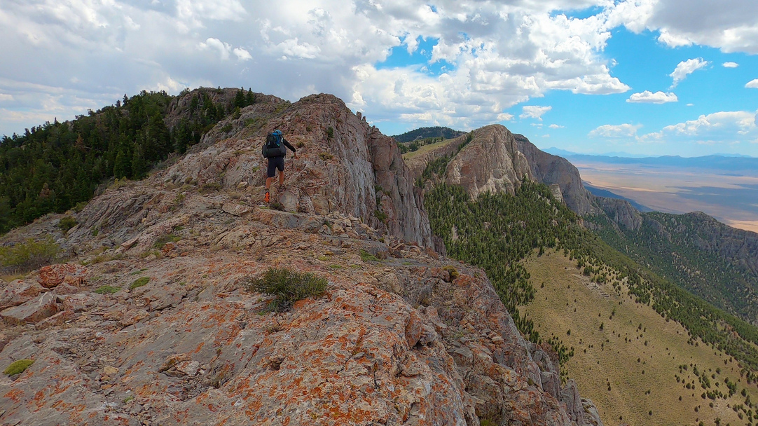
This is the northernmost section of the BRT. Heading east from Wells, the route turns south into the Precoup Range and follows the crest, providing sweeping views of Independence and Goshute Valleys. The wreckage of an F-111 fighter jet can be found in the hills if you are lucky enough to stumble across it. The route turns east and crosses Goshute Valley, perhaps one of the driest sections of the BRT. Head up to Morgan Pass and walk the crest of the Goshute Range south, until you give up and head down to walk around! The bushwahcking here is intense, but the views will stay with you forever. The seas of golden grass in Goshute Valley offer a different kind of beauty. This is a tough range, with prolonged and intense bushwhacking. The views are among the best of the whole route, with the massive (30,000 acres) Bonneville Salt Flats to the east looking into Utah, the vastness of Goshute Valley to the west, and imposing limestone cliffs and ridges beneath your feet, stretching to the horizon north and south. After reaching US 93 ALT, it's a 35 mile hitch into Wendover.
Basin And Range Trail Section 8 Overview Map


Basin and Range Trail Section 8 - Route Description
After leaving Wells, the route takes a direct path east towards the Pequop Range. The Pequop Range begins with a subtle, gentle beauty... a play of light and shadows across vast, empty valleys, distant mountains line the horizon. Soon, the surprisingly good network of 4x4 roads, horse trails and mountain bike trails provide ample access to the high country, where the views really open up. The Pequops are east to overlook when it comes to planning a BRT thru hike, with so many other great ranges along the route. However, you will be pleasantly surprised with this range. Not only is it very hikeable, but you will really enjoy walking the crest here. If you are lucky, you may stumble upon the well preserved wreckage of an F-111 fighter jet in these mountains.
Several route options exist from here, but the current "standard route" does a complete traverse of the Pequop Range down to Little Lake Pass. Here, a couple of small game guzzlers provide the only potential water source around, so fill up here. This section is perhaps the driest along the entire route. Next, head over Flower Pass, which has a 1 mile long railroad tunnel running through the hills beneath your feet. From here, it's a 14 mile walk across Goshute Valley. This valley is different than many others along the Basin and Range Trail. Instead of the typical sagebrush, this valley is a much more appealing golden grass. When the light shines on it just right, wow! It can be a magical place. The Pony Express and Overland Routes also run through this valley.
Make your way into Johnson Canyon in the Bluebell Wilderness Study Area, down Erickson Canyon and south to Morgan Basin for water. Now, climb back up to Morgan Pass and begin an epic ridge walk through the Goshute Range. The first few miles start off along some horse trails and offer an encouraging outlook on the rest of the range. While the beauty of it continues, the ease of access deteriorates. Upon reaching a natural arch, you'll need to scramble to the crest, where the real adventure begins. Now, you will begin to question how many others have set foot here before you. Pilot Peak to the north dominates the horizon, while the views east into the 30,000 acre Bonneville Salt Flats are unlike anything along the rest of the route, and will redefine your definition of vast.
By the time you reach your first and only water source in the Goshutes, you have a decision to make. By now, you have already completed the most grueling bushwhack of the BRT, a 1 mile thicket of curl leaf mountain mahogany trees on steep slopes. A low route exits to bypass the guaranteed bushwhack ahead, or, take the unverified ridge route over Goshute Peak an Mt. Pisgah for more great views and thick bushwhacks. The low route itself is pleasant, walking the base of these impressive mountains in the shadows of limestone cliffs and caves. This section ends at US 93 Alt, where you hitch into Wendover to resupply.